Paper escaper
This is true data-free roaming. Gordon Cruickshank outs himself as a proud cartophile for some very cheap thrills

1

2

3

4

5

6

7

8

9

10

11

12

13

14

15

16

17

18

19

20

21

22

23

24

25

26

27

28

29

30

31

32

33

34

35

36

37

38

39

40

41

42

43

44
45

46

47

48

49

50

51

52

53

54

55

56

57

58

59

60

61

62

63

64

65

66

67

68

69

70

71

72

73

74

75

76

77

78

79

80

81

82

83

84

85

86

87

88

89

90

91

92

93

94

95

96

97

98

99

100

101

102

103

104

105

106

107

108

109

110

111

112

113

114

115

116

117

118

119

120

121

122

123

124

125

126

127

128

129

130

131

132

133

134

135

136

137

138

139

140

141

142

143

144

145

146

147

148

149

150

151

152

153

154

155

156

157

158

159

160

161

162

163

164

165

166

167

168

169

170

171

172
Remember maps? If you weren’t born till the ‘90s, imagine printing out your satnav. The rest of us can recall wrestling with large sheets of paper that refused to return to their original folds – and some of us still keep an atlas in our cars. You can’t explore aimlessly with satnav. (I’m no Luddite: I do use GPS but avoid paying costly ISP data charges by downloading OSM maps – it’s free and you don’t need to be online.)
While last year’s road atlas is simply outdated paper, a 1930s map can be an enjoyable trip down that dusty Imagination Lane for us cartophiles, conveying images of traffic-free roads, quiet towns and empty countryside. In fact, the reality was terrible jams in Kingston or Newcastle, frequent punctures on gravel roads and filling stations closed on Sundays. But never let the facts get in the way of a daydream, and you can feed those daydreams by collecting old maps. Once the car was let loose on the roads, mapmakers soon realised they could tailor their products to the new freedom. Some merely added a cover illustration of a car to a cycling map, but many were useful guides, following Michelin’s lead from 1900 in offering details of garages, filling stations and repair depots – all things it was wise for the early motorist to know about.
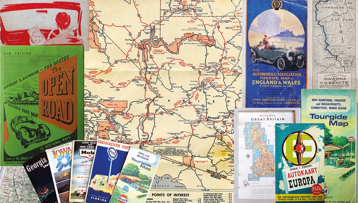
By the 1920s motoring had become a pastime, with maps from cartographers like Bartholomew and Ordnance Survey, from petrol companies, the AA and RAC, tyre makers, car marques, newspapers, even the Co-op. Shell published its lauded County Guides series from 1934, handy books of cultural and historical information supported by a succession of maps. (Don’t try to collect guides for every UK county – the series was never finished.) You might, though, aim to collect all the Shell county maps, the complete set of BMC gazetteers from the 1950s (there was a map boom postwar), or maps just of Wales. Perhaps you could chase maps by rare and vanished petrol suppliers such as Regent, ROP or Nafta. Check out Petrol Maps (petrolmaps.co.uk) for links. Few of these will cost more than a couple of pints of beer.
One of the attractions of early sheet maps is cover artwork, often romantic depictions of the area covered making them ideal for display. American maps, given away free by the million at gas stations, were rich in scenic covers, notably Esso and Chevron. Many US collectors focus on one state, or individual oil companies, or even their birth year.
As well as sheet road maps and atlases, motorists could buy touring guides detailing local sights, hotels and hostelries – fun to see how many survive – and recommended route guides, offering pre-plotted trips with timings and stopping points. Reader’s Digest’s Book of the Road became a modern gazetteer, mixing maps with everything from inn signs to wildlife; early examples from the 1970s cost just a few pounds.
“A 1930s map can be a trip down that dusty Imagination Lane”
Maps came in a large range of formats: atlases, hard- or soft-backed, glovebox-sized and pocket-sized. There have also been a few attempts at strip maps, detailing popular routes in a linear format. A 1975 Shell example covered the M1 twice, both right way up and upside down – you rotated it for northbound or southbound trips.
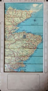
There were also some brave forays into technology aimed at making your map easier to manage. A flapping fold-out is a liability in an open car, and hard to handle by the solo driver. One solution was the 1950s Roll-o-Mapic, its clear plastic case containing a long roll of an entire country which you wound from section to section. Rare and interesting yet not a wallet breaker at £20-30. A cleverer variant dating to around 1960 was Auto-Mapic, in a similar plastic case, but by sliding side tabs up and down different map sections appear in the window. Hard to describe but there’s a YouTube video. It’s ingenious and fun – I have one and I’m dying to take it apart see how it works. Again uncommon but not pricey.
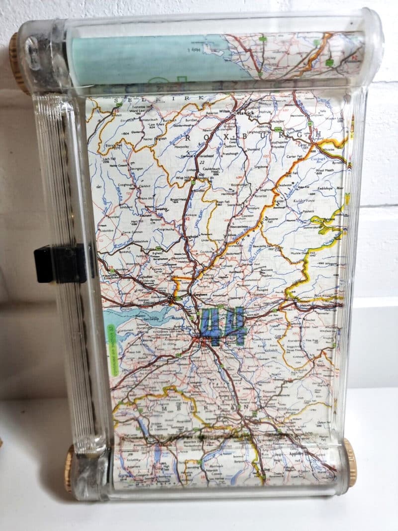
The Roll-o-Mapic device used twin rollers to cover the country, with a clever fast-wind system
If you think this is a niche sport, look up the Road Map Collectors Association (roadmaps.org) in the US: their annual ‘Mapcon’ get-together with lectures and sales stalls, often at the huge Hershey Autojumble, should prove you’re one of many map lovers. But only the serious cartophile will be able to track down the deliberate errors mapmakers include to trap copiers. However, if you send me cash in a brown envelope I can reveal the places where bored cartographers have secretly inserted their names on OS maps. And that’s true.
Auto-MapicNovel attempt at compact route plotting – 1960ish Auto-Mapic. Side tabs make map sheets magically interchange within clear double-sided case showing a different map on each side. For Sale |
|
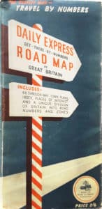
Travel by numbersHelpful Daily Express map in case you didn’t realise A-roads were numbered. Although it does illustrate that they are numbered in clockwise sectors, unknown to many. For Sale |
|
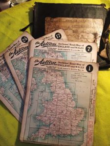
Autocar sectionalEven magazines offered maps. Unusual 1920s Autocar sectional UK maps to be slotted behind the clear case window. Case poor but all parts present. For Sale |
|
Germany guideInformative travel guide for Germany, dated around 1959, with traffic law and signage information plus a fold-out map of the whole country. Unusual. For Sale |

|
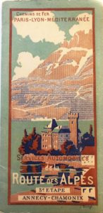
Roads by railCross-Alpine road route published by French railways around 1920, Annecy to Chamonix section. Attractive colour front and rear cover artwork. For sale |
|